Log in
All resources
Create a design
10,904 Free Images of Engraved Maps
copper engraving print
british library
joan blaeu
baroque
maps from the earth and its inhabitants, vol. iv
1667 maps
national library of poland
miniature speed atlas (1627) pieter van den keere
pieter van den keere
engravings of topographia braunschweig lüneburg
maps of rivers of senegal
bafing river
maps from the earth and its inhabitants, vol. x
19th-century maps of egypt
maps from the earth and its inhabitants, vol. xii
maps of icebergs
maps from the earth and its inhabitants, vol. viii
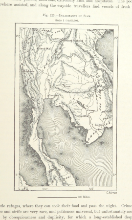
demographic maps of thailand
maps from the earth and its inhabitants, vol. iv
maps of loch fyne
maps from the earth and its inhabitants, vol. vii
maps of the yellow river
maps from the earth and its inhabitants, vol. iv
old maps of newcastle upon tyne
maps from the earth and its inhabitants, vol. vii
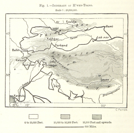
maps of xuanzang's travels
maps from the earth and its inhabitants, vol. ix
maps of telegraph lines
maps of the western cape
breede river
maps from the earth and its inhabitants, vol. xi
maps indicating exploration
print room of the university of antwerp
citadel van antwerpen
maps of the divisions of the polish-lithuanian commonwealth
karol de perthées
maps from the earth and its inhabitants, vol. vii
treaty ports
maps from the earth and its inhabitants, vol. iv
boston, england
maps from the earth and its inhabitants, vol. xvii
maps of louisville, kentucky
1600s maps of the world
copper engravings
civitates orbis terrarvm, liber primvs (1577)
maps of braunschweig by braun & hogenberg
maps of the dutch east india company - sri lanka
1750
maps from the earth and its inhabitants, vol. xvii
anton francesco lucini
maps from the earth and its inhabitants, vol. vi
latin-language maps
maps in the british museum
prints by mario cartaro
1830 maps of the united states
maps by george w. boynton
eran laor cartographic collection
engravings by frans hogenberg
miniature speed atlas (1627) pieter van den keere
maps of wales by john speed
atlas maior, vol 12 (america) - joan blaeu, 1667 - bl 114.h(star).12
1667 maps
atlas maior, vol 2 (sweden, russia, poland, eastern europe, and greece) - joan blaeu, 1667 - bl 114.h(star).2
17th-century maps of finland
miniature speed atlas (1627) pieter van den keere
maps of wales by john speed
atlas maior, vol 2 (sweden, russia, poland, eastern europe, and greece) - joan blaeu, 1667 - bl 114.h(star).2
1667 maps of russia
maps of haarlemmerhout
old maps of haarlem
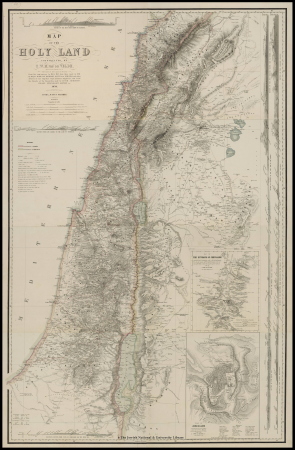
1858 van de velde maps of palestine and jerusalem
1850s maps of lebanon
maps by jodocus hondius
maps by petrus bertius
flemish prints in the rijksmuseum amsterdam
maps of amersfoort by braun & hogenberg
maps from the earth and its inhabitants, vol. xv
exploration of the arctic
prints in the national gallery of art (washington, d.c.)
francesco zucchi
engravings of topographia braunschweig lüneburg
baroque
atlas maior, vol 1 (northern europe, norway, and denmark) - joan blaeu, 1667 - bl 114.h(star).1
1667 maps
17th-century maps of southeast asia
maps by jodocus hondius
map of amsterdam by julius milheuser after daniël stalpaert, 1662
julius milheuser
map of amsterdam by julius milheuser after daniël stalpaert, 1662
julius milheuser
map of amsterdam by julius milheuser after daniël stalpaert, 1662
julius milheuser
map of amsterdam by julius milheuser after daniël stalpaert, 1662
julius milheuser
1780s maps of berlin
1786 maps of berlin
de praecipvis totivs vniversi vrbibvs, liber secvndvs (1612)
maps of dunkerque by braun & hogenberg
atlas sive cosmographicae (gerardus mercator, 1596)
16th-century maps of colombia
engravings of topographia braunschweig lüneburg
baroque
engravings of topographia braunschweig lüneburg
baroque
19th-century maps of vaucluse
1852 maps of france
19th-century maps of crimea
g. h. swanston
maps of portugal by fernando álvares seco
maps
engravings of cities
baroque
maps in the british museum
1610s maps of ireland
topographia westphaliae (merian)
baroque
atlas maior, vol 4 (netherlands) - joan blaeu, 1667 - bl 114.h(star).4
1667 maps
atlas maior, vol 6 (scotland and ireland) - joan blaeu, 1667 - bl 114.h(star).6
1667 maps
atlas maior, vol 11 (asia) - joan blaeu, 1667 - bl 114.h(star).11
1667 maps
engravings of topographia braunschweig lüneburg
baroque
maps of barbary coast by mercator-hondius
conquest of majorca
atlas van der hagen (volume 2)
atlas van der hagen
18th-century maps of barbados
1780 maps of the caribbean
liber qvartvs contrafactur vnd beschreibung von den vornembsten stten der welt (zzk 0.32)
patrimonium 2 (project)
liber qvartvs contrafactur vnd beschreibung von den vornembsten stten der welt (zzk 0.32)
patrimonium 2 (project)
map of bruges by marcus gheeraerts (i)
engravings
1780s maps of the world
german renaissance
saxony in the 1640s
baroque
1780s maps of berlin
1786 maps of berlin
de praecipvis totivs vniversi vrbibvs, liber secvndvs (1612)
maps of tunis by braun & hogenberg
atlas maior, vol 10 (spain and africa) - joan blaeu, 1667 - bl 114.h(star).10
1667 maps
atlas maior, vol 9 (italy) - joan blaeu, 1667 - bl 114.h(star).9
1667 maps of italy
turgot map of paris, norman b. leventhal map center – derivative files
rue de braque on maps
atlas sive cosmographicae (gerardus mercator, 1596)
16th-century maps of colombia
andalusia in the 1610s
francisco heylan
moïse-jean-baptiste fouard
corsair wars
maps of bergen (norway) by braun & hogenberg
1580s engravings
1870s maps of the caucasus
g. h. swanston
engravings of topographia braunschweig lüneburg
baroque
atlas maior, vol 6 (scotland and ireland) - joan blaeu, 1667 - bl 114.h(star).6
1667 maps
1858 van de velde maps of palestine and jerusalem
eran laor cartographic collection
prints in the national gallery of art (washington, d.c.)
francesco zucchi
maps in the british museum
prints by mario cartaro
maps from the earth and its inhabitants, vol. iv
maps of kirkwall
maps of the western cape
breede river
maps from the earth and its inhabitants, vol. iv
mouth of tay
maps from the earth and its inhabitants, vol. iv
maps of portland, england
maps from the earth and its inhabitants, vol. xi
maps indicating exploration
maps from the earth and its inhabitants, vol. ix
maps of telegraph lines
maps from the earth and its inhabitants, vol. iv
maps of loch fyne
maps from the earth and its inhabitants, vol. xiii
ethnographic maps of africa
old maps of south africa
maps of the great trek
maps of rivers of senegal
bafing river
maps from the earth and its inhabitants, vol. xii
maps of icebergs
maps from the earth and its inhabitants, vol. x
19th-century maps of egypt
miniature speed atlas (1627) pieter van den keere
county maps of england by john speed
miniature speed atlas (1627) pieter van den keere
county maps of england by john speed
old maps of piedmont
maps by gerard valck
miniature speed atlas (1627) pieter van den keere
county maps of england by john speed
maps of the west-indische compagnie
1668
engravings of topographia palatinatus rheni
baroque
maps from the earth and its inhabitants, vol. vi
charles eugène perron
maps from the earth and its inhabitants, vol. xvii
maps of louisville, kentucky
1801 - 1900 of 10,904
Next page
/ 110